 Introduction to GPS
 Global Positioning System
(GPS)
 |
The Global Positioning System is a space-based triangulation system using satellites and computers to measure positions anywhere on earth. It is first and foremost a defense system developed by the United States Department of Defense, and is referred to as the 'Navigation Satellite Timing and Ranging Global Positioning System' or NAVSTAR GPS. The uniqueness of this navigational system is that it avoids the limitations of other land-based systems such as limited geographic coverage, lack of continuous 24-hour coverage, and the limited accuracies of other related navigational instruments. The high accuracies obtainable with the Global Positioning System also make it a precision survey instrument. |
Space
Segment
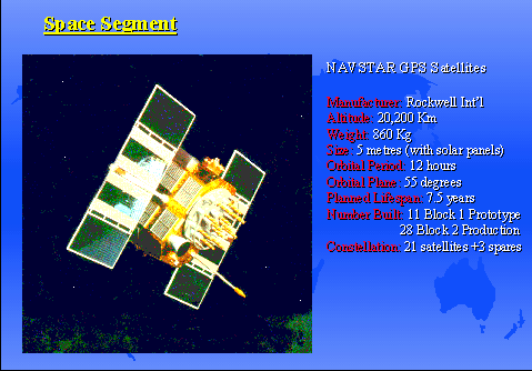 |
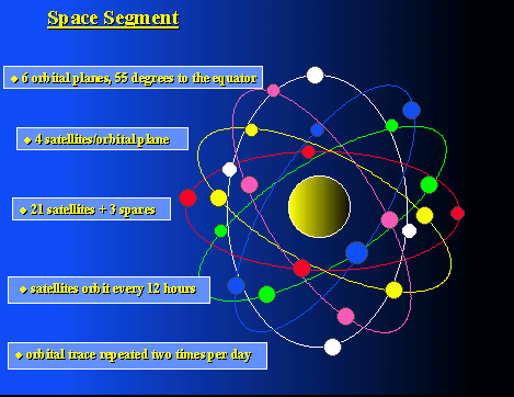
The Space Segment consists of a constellation of 24 satellites, orbiting in 6 planes oriented at 55 degrees to the equator. Each orbital plane contain 4 satellites at an elevation of 20,200 kilometers above the earth. The 24 satellites form part of the Blocks II satellite constellation and are produced by Rockwell International, Satellite Systems Division. The Block I constellation, the predecessor to the current GPS Block II constellation, was transitory and experimental in nature with a focus on military applications; the current constellation has both defense and commercial application. |
| Each Block II satellite weighs 844 kilograms and has a design life of 7.5 years. Each satellite is about the size of a large van with each solar panel covering a surface area of 7.2square metres. The satellites contain two rubidium and two cesium atomic clocks, and three nickel-cadmium batteries which provide energy during eclipse periods. The satellites have an orbital period of 12 hours such that they complete 2 orbital revolutions within a 24 hour period while the earth rotates 360 degrees. This results in a trace of the satellite orbit on the earth's surface which will repeat itself daily. Thus, the positions of the satellites in the sky at any location can be defined for any particular period of time. |
Control
Segment
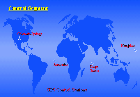 |
The Control Segment is responsible for operating the Global Positioning System. The GPS Master Control Station (also known as the Consolidated Satellite Operations Center - CSOC) is located near Colorado Springs, Colorado. The primary mission of the control segment is to update the navigational message of the satellites. In order to achieve this the Master Control Station has monitoring stations distributed around the world which continuously track the satellites in view. Information on the satellites is then transmitted to the Master Control Station where computations are made and an up-to-date navigation message is uploaded to the satellites; there may be several uploads per day per satellite. |
| As soon as satellites are added to the operational constellation, the Master Control Station implements a method of control which limits civilian access to the system's full capabilities. This method of control is referred to as 'Selective Availability'. The method involves introducing slowly varying time errors by "dithering" the satellite clock, and by altering the navigational message (the satellite orbital data). The Master Control Station operates under the specifications of a 3-D positional accuracy of 16 metres with full access to the P-code (for military uses), and 2-D civilian accuracy of 100 metres with degradation of the C/A code by Selective Availability. |
User
Segment
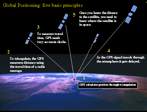 |
GPS Receivers are hand-held radio-receivers/computers which measure the time that the radio signal takes to travel from a GPS satellite until it arrives at the GPS antenna. Using the travel time multiplied by the speed of light provides a calculation of range to each satellite in view. From this and additional information on the satellites orbit and velocity, the internal GPS receiver software calculates its position through a process of triangulation. |
| Military Use: Precise Positioning Service (PPS) Receivers are for military use. They are military equipment and require encryption keys to operate at their full level of accuracy. PPS receivers track the precise (P) code on two frequencies in order to correct for delay of the signal through the upper atmosphere (ionosphere) | |
| Civilian Use: Standard Positioning Service (SPS) Receivers are for civilian use. they are designed to track the coarse-acquisition (C/A) code broadcast by the satellites. The SPS receivers provide 100 metre accuracy under good satellite geometry. |
| GPS Accuracy | GPS Receivers |
| Inaccuracies imposed by the U.S. Department of Defense (Selective Availability or S/A) and due to atmospheric and timing errors limit the accuracy of a single GPS receiver to +/- 50 metres. However, there are methods which can be use to provide accuracies of +/- 5 metres. These method uses a known position, such as surveyed control point, as a reference point to correct the GPS position error. These methods of correcting GPS positions are referred to as Differential GPS or DGPS. The DGPS corrections can be applied to the GPS data in real-time using data telemetry (radio modems) or can be done later on a PC. The U.S.A. and Candian Coast Guard are establishing a series of radio beacons to transmit the DGPS corrections for accurate navigation along the Great Lakes, the Mississippi River and tributaries, the Gulf Coast,and the Eastern and Western coasts of North America. | There are a variety of different types of GPS receivers on the market for commercial and public use. Prices range from $500-$30,000, reflecting the accuracy and capabilities of the instruments. For the general outdoorsman, a good GPS receiver should have 8 satellite tracking capability and be capable of receiving the GPS satellite signals through forest canopy in northern Ontario shield terrain; for the professional user, a minimum 8 satellite tracking capability, high memory capacity, differential GPS capability, and resistance to signal dampening under forest canopy is essential; for the professional surveyor requiring high level precision and accuracy capability, they should assess the project or application for which the technology is to be used with the help of an unbiased consultant, in order to determine the most cost effective and appropriate instrument. |