
Regional Geology & Property Location
|
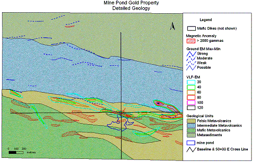
Geology -
Property situated in the south central part of the
Batchewana Greenstone Belt, -
Gold mineralization is hosted by volcanic-exhalative
horizon (lean iron formation) within interfingered mafic to intermediate
metavolcanic rocks, -
Host rocks offset by NNE-trending gold-bearing fault
zones; extensive remobilization of iron formation resulting in higher gold
grades (see below) -
Mine Pond gold prospect characterized by coincident
magnetic, VLF and MaxMin anomalies, -
Anomalous gold targets from till sampling program remain
to be tested. |
Geological/Structural Model
|
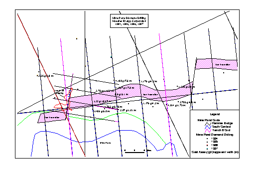
Assay Results -
Diamond drilling in 1984,85,86 & 87 outlined
near-surface mineralized zone extending over 200 m long and 10 m apparent
width -
Significant intersections (apparent width): 0.21 opt over 20 feet;
0.12 opt over 25 feet; 0.25 opt over 16 feet (see reverse side for details) -
Surface trench assays up to 0.41opt over 2 ft width, -
Conductive horizon can be trace 1 km east and west of main
mineralized zone, -
Diamond drill core available for logging and re-sampling at the OGS
DCL. |
Contact: Delio Tortosa
R.R.#1, 110 Robertson Lake Road
Goulais River, Ontario P0S 1E0
![]()
![]()
![]() Tel:
(705) 649-0763 Email: eliris@soonet.ca
Tel:
(705) 649-0763 Email: eliris@soonet.ca
Gold
Grade: Selected Diamond Drill Hole Intersections,
Mine
Pond Gold Property
(NOTE: Drill hole intersections
represent apparent width)
|
Hole No. |
Metric |
Imperial |
|
BPC-86-04 |
1.775
ppm/13.1 m |
0.052
opt/42.9 ft |
|
86-04 |
3.086 ppm/3.5 m |
0.090 opt/11.5 ft |
|
BPC-86-03 |
1.486
ppm/5.0 m |
0.043
opt/16.4 ft |
|
BPC-85-05 |
1.762
ppm/5.76 m |
0.051
opt/18.9 ft |
|
BPC-86-07 |
1.807
ppm/17.9 m |
0.053
opt/58.7 ft |
|
BPC-86-08 |
2.636 ppm/14.8 m |
0.077 opt/48.4 ft |
|
86-08 |
4.189 ppm/7.6 m |
0.122 opt/24.8 ft |
|
BPC-86-10 |
1.782
ppm/10.7 m |
0.052
opt/35.2 ft |
|
86-10 |
2.915
ppm/3.3 m |
0.085
opt/11.0 ft |
|
BPC-86-11 |
1.176
ppm/4.2 m |
0.034
opt/13.9 ft |
|
BPC-86-20 |
2.118
ppm/5.0 m |
0.062
opt/16.4 ft |
|
BPC-86-14 |
7.158 ppm/6.0 m |
0.209 opt/19.7 ft |
|
BPC-86-15 |
4.014 ppm/1.75 m |
0.117 opt/5.7 ft |
|
BPC-86-16 |
4.308 ppm/3.1 m |
0.126 opt/10.0 ft |
|
BPC-86-17 |
2.705
ppm/4.0 m |
0.079
opt/13.0 ft |
|
BPC-86-21 |
1.593
ppm/3.0 m |
0.046
opt/9.8 ft |
|
BPC-86-19 |
1.200
ppm/4.0 m |
0.035
opt/13.0 ft |
|
86-19 |
2.29
ppm/1.0 m |
.067 opt/3.3
ft |
|
BPC-85-3 |
1.23
ppm/18.5 m |
0.036
opt/60.6 ft |
|
85-3 |
2.46
ppm/4.9 m |
0.072
opt/16.1 ft |
|
BPC-85-4 |
1.74
ppm/6.83 m |
0.051
opt/22.4 ft |
|
BPC-85-11 |
2.07
ppm/1.81 m |
0.06
opt/5.9 ft |
|
BPC-85-12 |
1.95
ppm/1.35 m |
0.057
opt/4.4 ft |
|
BPC-85-5 |
2.76
ppm/11.63 m |
0.08
opt/38.2 ft |
|
85-5 |
3.32
ppm/4.88 m |
0.097
opt/16.0 ft |
|
BPC-85-6 |
1.47
ppm/12.61 m |
0.043
opt/41.4 ft |
|
BPC-85-7 |
1.27
ppm/14.33 m |
0.037
opt/44.36 ft |
|
85-7 |
2.33
ppm/2.63 m |
0.068
opt/8.63 ft |
|
BPC-85-9 |
2.37 ppm/14.1 m |
0.069 opt/46.3 ft |
|
85-9 |
3.6 ppm/5.1 m |
0.105 opt/16.8 ft |
|
BPC-85-10 |
3.54 ppm/20.46 m |
0.103 opt/67.5 ft |
|
85-10 |
8.43 ppm/5.01 m |
0.246 opt/16.4 ft |