Topic 4: Vertical Aerial Photography
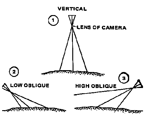
Aerial Photography can be divied into two categories: Vertical and Oblique.
Vertical Aerial Photos: the axis of the camera (and lense) is
perpendicular to the ground. The greates amount of information can be derived from
vertical airphotos.
Oblique Aerial Photos: the axis of the camera/lense is tilted at
an angle from 3 to 90 degrees to the ground. Scale is constantly changing from the
foreground to the background.
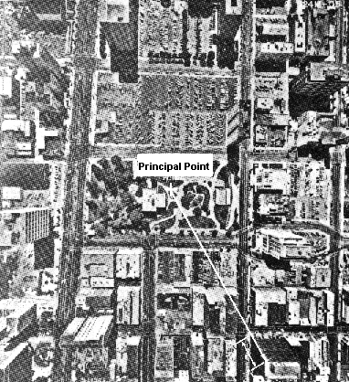
As noted in an earlier lecture, an airphoto derived from a camera is a Perspective View. This means that there is distortion in the image due to image motion and image displacement due to topography and the effect of Parallax. The geometric centre of the airphoto, or Principal Point, has no image displacement. This position on the ground is referred to as the Plumb Point or Nadir. Radially and towards the margins of the airphoto, the image displacement increases due to the effect of parallax.
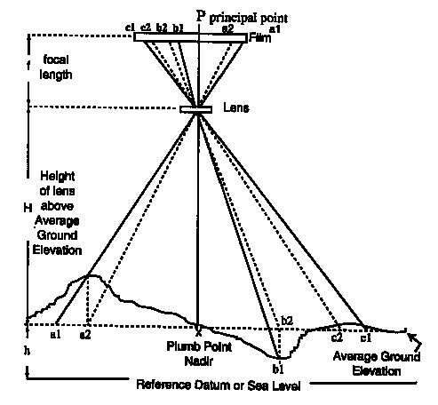
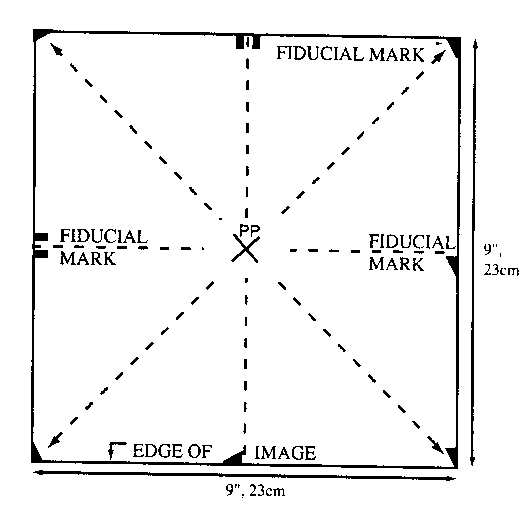
In order to identify the location of the Principal Point on an airphoto, Fiducial Marks are photographed each time an image is recorded. Thelocation of the Principal Point can then be determined by the intersection of straight lines between opposite fiducial marks.
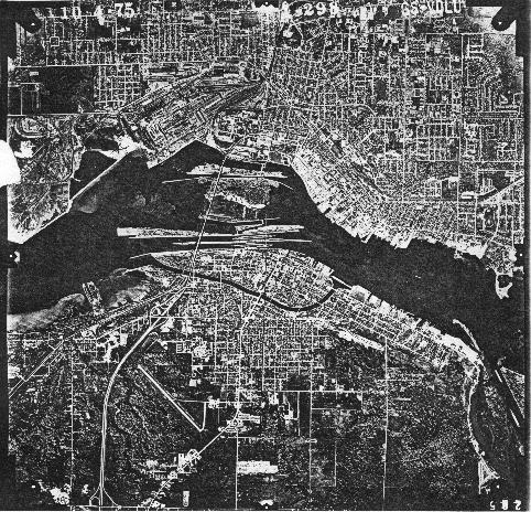
Sault Ste. Marie Airphoto Example
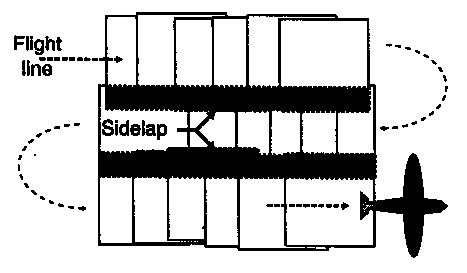
Aerial photos are generally taken in a North-South or East-West direction along parallel flightlines.
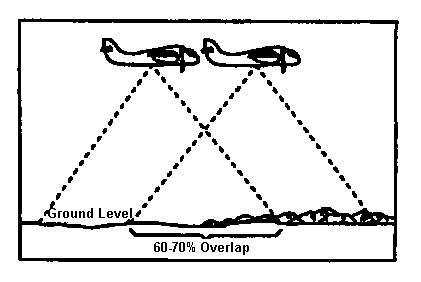
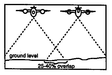
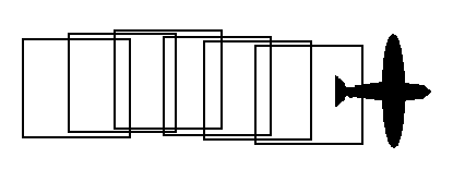
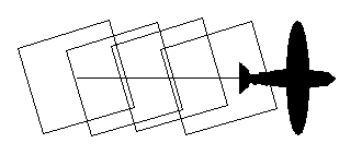
Flight Lines: are the paths that an aircraft takes in order to ensure complete coverage of the area to be photographed. Flightlines are arranged to give a succession of overlapping photos. The photos overlap within and between flightlines, and the overlap in these two directions is called Forward Overlap (or Endlap) and Sidelap.
Forward Overlap within a
flightline is from 60 to 70%. This provides for stereoscopic view of the area and complete
coverage.
Sidelap between flightlines is from 25-40% and ensures that no areas are left unphotographed.
There are two main causes of unsatisfactory ground coverage: Drift and Crab.
Drift is the lateral shift of the aircraft from the flightline; this may be caused by pilot error or the effect of wind on the aircraft.
Crab occurs when the aircraft is not oriented with the flightline; photo edges are not parallel to the flightline and it usually occurs when the pilot is trying to compensate for a cross wind and orients the plane into the wind to maintain the flightline.
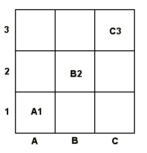
In order to quickly locate objects or areas of interest on an airphoto the USGS has used an feature indexing method called the A,B,C Location Method. The method uses a grid cell system with an X axis divided into A,B,C etc. and a Y axis divided into 1,2,3 etc.
There are two methods which can be used to determine the scale of an airphoto:
Arithmetic Proportion: It is possible to determine Photo Scale
by comparing an object or distance between two points on the airphoto (Photo
Distance) with the same object or points on a topographic map (True
Ground Distance).
PHOTO SCALE = Photo Distance / True Ground Distance
Both the Photo Distance and the Ground Distance must be in the same units i.e. feet or meters. This ratio is the same as the Representative Fraction. Another way of expressing the relationship uses the following equation:
Map Measurement/Map RF = Photo Measurement/Photo RF
Photo RF = (Photo Measurement/Map Measurement)* Map RF
NOTE: The Map and Photo measurements must be in the same units i.e. inches or cm
Camera-Altitude Relationship: It is possible to determine the
Photo Scale by knowing the camera focal length and aircraft
height. The relationship between focal length, and aircraft height is given
by:
PHOTO SCALE = focal length / aircraft height
Both the Camera Focal Length and the Aircraft Height must be in the same units i.e. feet or meters. This ratio is the same as the Representative Fraction.
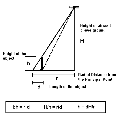
Height Determination from Airphotos
There are two methods which can be employed to determine the height of objects: the Single Photo Method and the Stereopair Parallax Method.
Single Photo Method is the simplest to use, but generally applicable only to vertical features where the top an bottom of the feature can be observed.
The method uses the principle that the radial displacement of a feature varies proportionately with the height of the aircraft and is determined by the formula: h = dH/r
Airphoto Example
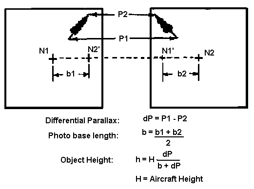
Parallax Method of Height Determination
This method requires two overlapping airphotos on the same flight line, the height of the aircraft above the ground, and the average photo base length. The photo base length is the distance from the geometric center (or Principal Point) of one airphoto to the other.
The method uses the principle that the radial displacement of a feature varies proportionately with the height of the aircraft, but takes into account measurements from two airphotos thereby providing greater accuracy in the result.
Arnold: p. 7-13
p.
23-35