Map Projections and Coordinates Systems
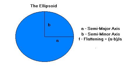
The shape of the Earth is best described as an imperfect sphere which bulges at the equator and flattens at the poles. It can be mathematically modelled by an Ellipse (in 2 dimensions) and an Ellipsoid (in 3 dimensions).
Latitude and Longitude Coordinates
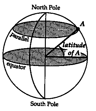
In order to describe positions on a sphere we use the Latitude, Longitude coordinate system.
Latitude is the angular distance of a point away from the equator measured from the center of the globe 90 degrees North (0 to +90) or South (0 to -90) .
Determination of Latitude:
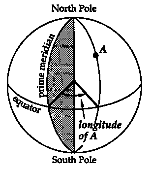
Longitude is the angular distance of a point from the Principal Meridian measured from the center of the globe 180 degrees East (0 to +180) or West (0 to -180). The Principal Meridian is also referred to as the Prime Meridian or Greenwich Meridian.
Determination of Longitude:
Map projections are a representations of a sphere (the Earth) in two dimensions. A mathematical transformation is required in order to convert Latitude & Longitude coordinates into Cartesian Coordinates on a two dimensional surface. This transformation results in distortions of the original three dimensional surface in two dimensional maps.
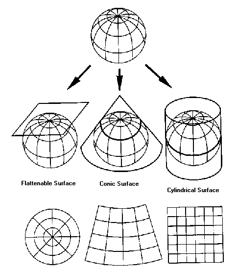
Distortions result in changes to the shape, size, area, and direction on a map.
Conformal Projections are characterized by shape retention (i.e. Lambert Conformal Conic). So that a small circle on globe will remain a circle on the projection, but the scale or size may be different.
Equal Area (or Equivalent) Projections are characterized by area retention (Albers Equal Area Conic). So if South America is eight times larger than Greenland on the globe, it will also be eight times larger in the projection.
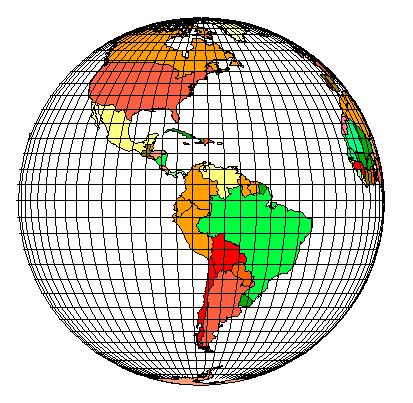
Orthographic Projection (Equatorial): Preserves the appearance of a globe and shows only half the Earth at a time. Distorts shape and direction and is useful for illustrations.
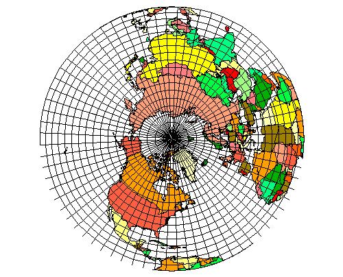
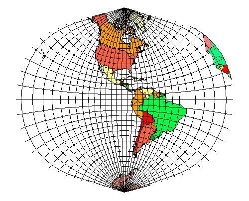
Planar (Azimuthal) Projection (Lambers Equal Area Azimuthal Projection): Used to represent the projection of a region (northern hemisphere) onto a plane tangent to the globe, in this example, the north pole is used.
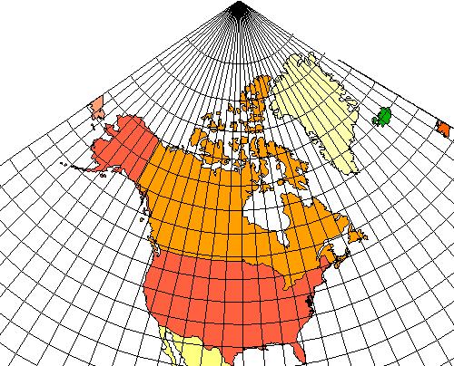
Conic Projection (Lamber Conformal Conic): Made by fitting a cone over part of the globe. The projection depicts mid-latitudes shapes and areas well. It is used to depict large regions up to the size of the USA.
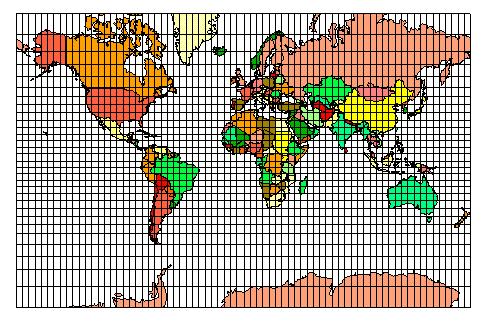
Cylindrical Projection (Mercator): is based on a cylinder tangent to the equator. Good for equatorial regions but greatly distorted at high latitudes. This one of the oldest and most common projections
Transverse Cylindrical Projection (Universal Transverse Mercator, UTM): is based on a cylinder tangent to the globe along a chosen pair of opposite meridians. The scale of the map is constant only along the central meridian.
UTM is a commonly used projection for USGS maps ranging in scale from 1:24,000 to 1:250,000. The UTM projections are based on 60 UTM Zones each defined by a central meridian and covering 3 degrees of Longitude to the East and West.
Maps based on the UTM Projection have a Cartesian Coordinate grid system which is used to define any point on the map. Positions are defined by the UTM Zone, an 'X' coordinate called the Easting (in meters) and a 'Y' coordinate called the Northing (in meters). A typical example in the Upper Peninsula of Michigan would be:
UTM Zone: 16
Easting: 704019
Northing: 5149326
The Northing is the distance north (or south) from the Equator measured in metres; The Easting is an arbitrary reference line located 500,000 metres west of the Central Meridian. Easting measurements increase west from the reference line.
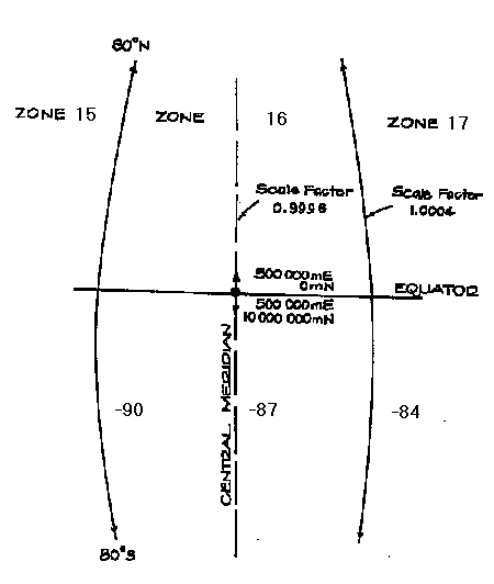
UTM Coordinates can measure position to the meter, making this an easy and accurate way of identifying locations on a map.
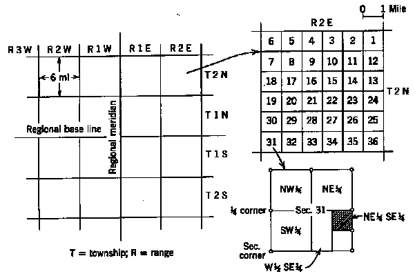
The US Public Land Survey System provides a descriptive way of describing an area or parcel of land. For example, in Michigan land is subdivided in terms of Counties, Townships, Sections, and Parcels. Baselines which run East-West and Principal Meridians which run North-South, form the X and Y coordinate axes. The location of townships is determined based on Township lines (north-south) and Range lines (east-west). Townships are subdivided into 36 Sections which are then subdivided into fractions.
Legal Description: a legal description of a tract of land requires note of the Meridian, Township, Range, Section and Fraction (generally in reverse order): for example
NE 1/4 of NE 1/4 of S32, T4N, R3E, Michigan Meridian
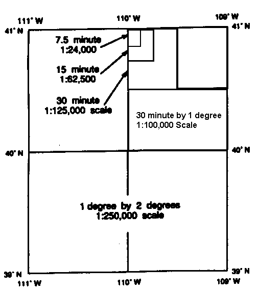
The United States Geological Survey subdivides topographic maps into rectangular areas called Quadrangles based on Latitude and Longitude lines (Meridians and Parallels). These Quadrangles vary in scale from the large scale 7.5' x 7.5' , 1:24,000 topographic maps to the small scale, 1 degree by 2 degrees, 1:250,000 topographic maps. Because these 'base' maps are used as the fundamental starting point for other types of surveys, many types of maps follow the same naming convention i.e. Geological maps, Land Use/Cover maps.