Forgotten North Shore Mining History
| For those of you who have traveled Highway 17 North from
Sault Ste. Marie and stopped at the Alona Bay scenic lookout, there is a historical plaque
at the site which commemorates the initial discovery of uranium in Canada by Dr. John Le
Conte in 1847 in the Alona Bay area (Nuffield, 1955). One hundred years later, in 1948, a
prospector by the name of Robert Campbell discovered the presence of pitchblende at the
promontory of Theano Point. This plaque provides a glimpse on an important period of
mineral exploration history, and a story which bears re-visiting now and then. |
 |
In 1949, the recently created Atomic Energy Control Board of Canada recommended
that the Federal Government lift the war-time restriction on private prospecting for
radioactive minerals. This was shortly followed by a large staking rush in the Lake
Superior - Montreal River area which led to a substantial amount of staking, prospecting,
mineral exploration, and underground development on several properties.Like the Lake Superior - Montreal River exploration play, a similar
exploration history was unfolding in the Beaverlodge area of northern Saskatchewan. As
will be noted later, the link between these two areas is not just in the historical timing
of events, but in the similar styles of uranium mineralization - what later came to be
known as ‘classical’ uranium vein deposits.
Rummaging through some of the old (historic) Ontario
Department of Mines Reports and assessment files on this area, it’s still possible to
find a few gems of information. This is particularly true of the report by E. W. Nuffield
(ODM Volume LXIV, Part 3, 1955), on the Geology of the Montreal River Area. |
- Montreal River Area Geology
Based on Nuffield’s report and detailed 1 inch to ˝ mile map, and my own,
more recent, visits to this area, the geology is dominated by massive to pegmatitic, late
Archean granite transected by west-northwest trending early Keweenawan-age, north dipping
diabase dikes. The granite and most of the diabase dikes are unconformably overlain by
mafic volcanics and red-beds of the Mamainse Formation which are in turn unconformably
overlain by siltstones and sandstones of the Mica Bay Formation. The Mica Bay Formation
has been correlated with the closing stages of the Keweenawan Midcontinental Rift and
represents the early part of the basin-fill clastic sequence which was later dominated by
the red sandstones of the Jacobsville Group (Late Keweenawan).
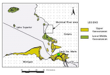
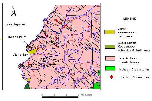
Location Map: Eastern Lake Superior and Montreal
River Area |
|
It is notable that throughout the eastern
shore of Lake Superior we have evidence for two major angular unconformities of
mid-proterozoic age: one below the Jacobsville - Mica Bay sediments and the other below
the Mamainse Formation volcanics.
- Montreal River Uranium Mineralization
Nuffield notes the close structural
relationship between the pitchblende-bearing veins and the tectonized contact between the
northerly dipping diabase dikes and enclosing granites. The mineralized veins range
anywhere from small Ľ" veinlets over a foot, up to several inches thick and 2 - 5
feet in length. The veins may occur at the sheared and brecciated contact with the granite
or cutting the diabase, but tend to preferentially occur at angles to the contact, within
granite. The veins consist of pitchblende, pink calcite, hematite and chlorite, with the
adjacent granite wallrocks altered to a brick-red colour for several inches due to
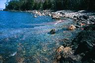
pervasive hematization. From my own field visits to the Theano Point area, the granites
and pegmatite segregations have an above normal radioactivity, attributed to the presence
of uranium refractory minerals such as uraninite. Nuffield identified a tantalum -
columbium bearing mineral within the radioactive granites (ellsworthite). We also found
large outcrop exposures where the feldspar crystals in the granite pegmatite were up to
one foot in length.
|
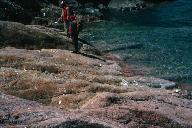
Granite pegmatite with large feldspar crystal (white reflections) located
near Theano Point pitchblende prospect; Paul Mora and Delio Tortosa in the far ground.
|
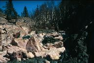
Theano Point pitchblende prospect;on the left is the granitic country
rock;on right is a Keweenawan diabase dike; contact is along steeply north dipping
fractures.
|
There is, apparently, no documented radiometric age
date for the pitchblende of the Montreal River area. Based on Nuffield’s geological
mapping, including geological sketches of mineral deposits together with geological maps
from the assessment files, the pitchblende-bearing veins and fractures transect both the
diabase dikes and the granites. They also appear to occur in fractures at the contact
between Keweenawan lavas and granite. From this we surmise that uranium mineralization was
likely early Keweenawan in age.
|
Generalized Geology of the
Montreal River area |
 |
Geological Comparisons with
Beaverlodge, Saskatchewan
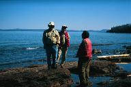
On a visit to Theano Point several years back with Mike Hailstone
and Paul Mora of the Sault District Office, I noted how similar these pitchblende veins,
vein minerals, and wallrock alterations were to uranium deposits and occurrences in the
Beaverlodge area of northern Saskatchewan. I had spent a number of years on exploration
programs in the Athabasca and Beaverlodge areas in the late 70’s, and so it was
somewhat of a ‘deja vu’ to encounter what appeared to be a striking similarity
both in structural style and geological setting between what I saw at Beaverlodge and that
at Montreal River.
Similar to Montreal River, Beaverlodge uranium deposits and
occurrences are structurally controlled near faults and occur as pitchblende veins and
breccias containing calcite, hematite, chlorite and with a characteristic brick-red
wallrock alteration imparted on the mylonitized basement rocks (granites, gneisses and
metasediments). The basement rocks are unconformably overlain by the Martin Group, a
red-bed clastic sequence intercalated with mafic to intermediate volcanics. Both the
basement rocks and Martin Group are unconformably overlain by the Athabasca Group, a
basin-fill sequence dominated by altered and predominantly fluviatile sandstones. Again
these rocks fall into a nearly mid-proterozoic age, and reflect two major mid-proterozoic
unconformities.
For both areas, there is an apparent close proximity between the
occurrence of pitchblende veins and the unconformity between basement rocks and the
younger basins. In both areas we see the development of red-bed fanglomerates and
sandstones with mafic to intermediate volcanics forming as a consequence of large-scale
tectonic fracturing, faulting and basin development.
Uranium Deposits and Unconformities
The close spatial proximity of uranium deposits to unconformities
is nothing new. It had been suggested by J. Robertson (1975) for the pitchblende
mineralization in the Montreal River Area, and by F. Joubin (1955) for Beaverlodge . The
most significant difference between Beaverlodge and Montreal River is the widespread
faulting, fracturing, and brecciation in the Beaverlodge area. There, brittle structures
hosting uranium veins developed along wide zones of regional-scale mylonitization. The
lack of well developed and pervasive structures in the Montreal River area resulted in
veins with very limited extent and therefore uranium deposits with sub-economic potential.
But the story doesn’t stop here.
The Athabasca Group: Uranium Elephant
Country
In Beaverlodge, the classical vein deposits represent the earliest
period of unconformity associated uranium mineralization (ca. 1780 My), which is also
roughly the age of the Martin Group. This was followed by a much more prolific period of
uranium mineralization (ca. 1100 My) associated with the younger series of continental
clastic sediments - the Athabasca Group. The Athabasca Group hosts some of the largest
and highest grade uranium deposits in the world.
What about our neck of the woods?
Back in our own neck of the woods, we’ve yet to discover anything
comparable to the deposits of the Athabasca. But once again, the geological setting
conducive to their development is not that dramatically different here. The Jacobsville
Group bears some resemblance in its depositional environment to that of the Athabasca
Group; both represent a craton-derived, predominantly fluvial clastic sequence variably
affected by diagenetic alteration. In the few places where the Jacobsville unconformity is
exposed, the underlying basement is characterized by a well-developed weathering profile -
with a hydrothermal overprint - similar to the sub-Athabasca basement weathering
(Kalliokoski, 1982).

|
Paleo Weathering Profile:
(from Kalliokoski, GSA Memoir 156. 1982)
Yellow: Jacobsville Formation
Red: Unconformity surface
Orange: Granodiorite
Blue: Peridotite
1: Perodotite
2: Blocky peridotite, supergene chert
3: Granodiorite
4: Diabase dike
5a,b: incipient weathering
5c: leached horizon
5d: Chert-rich lag deposit
6: Jacobsville sandstone |
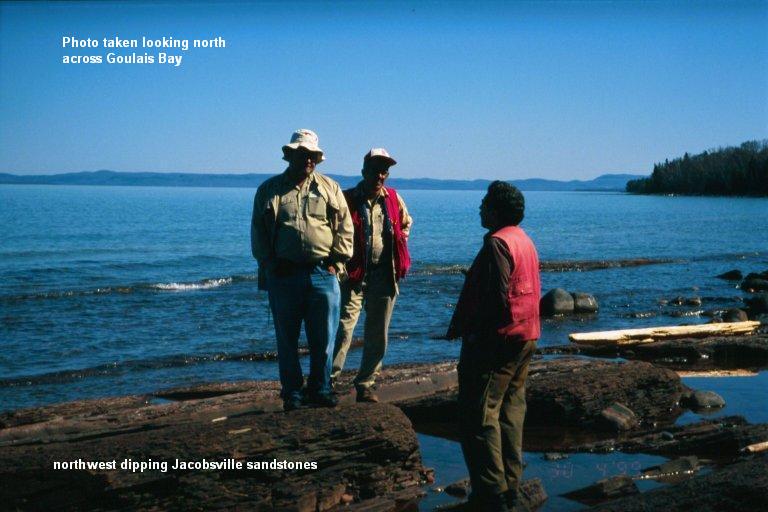
The Jacobsville Group: a potential
analogue to the Athabasca?
Standing on sandstone outcrop from left to right: Gerry Bennett, Paul
Mora, Delio Tortosa; Mike Hailstone photographer. |
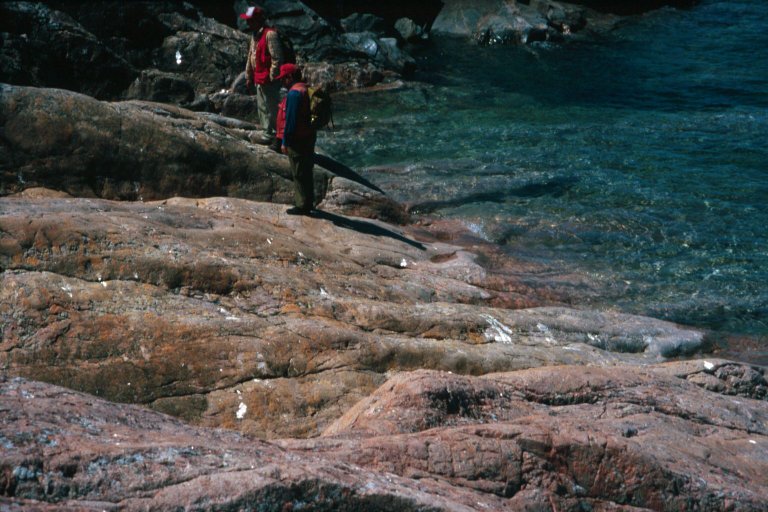
The Jacobsville/basement unconformity is not well exposed or
explored - that’s primarily because it lies under water (Lake Superior). In recent
years a few of us had an opportunity to explore the unconformity for a short distance on
the south shore of Goulais Bay due to the extremely low lake water levels. We were struck
by the extensive area of pseudomorphic alteration in the Archean gneisses immediately
below the shallow north dipping unconformity and basal conglomerates of the Jacobsville. |
|
|
| J. Kalliokoski (1976), had already noted the Athabasca -
Jacobsville similarities and suggested that meteoric waters and deep weathering could be
responsible for the potential development of unconformity-associated uranium deposits. He
pointed to the presence of some known radioactive occurrences found within soft iron ores
in Michigan which he suggests formed due to deep weathering. |
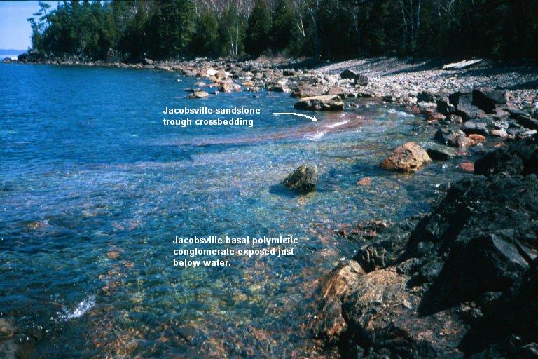
Shallow dipping Jacobsville sandstone overlies basal conglomerate;
unconformity outcrops parallel to the shoreline.
|
Exploration Guides for Elephant Country
One should keep in mind that the key to finding many of the ‘blind’
uranium deposits at the base of the Athabasca is the presence of graphitic conductors and
associated post-Athabasca fault structures. The general view is that graphite provides the
source of reductants which mixed with uranium-bearing, oxidizing, formational brines and
resulted in the deposition of pitchblende-rich plumes above the unconformity. With erosion
of the cover rocks the deposits for the most part disappear. Those that still remain are
protected due to the cover rocks and lie deep below the current surface. At surface there
is very little indication of what lies below.
Final Thoughts
Much of the previous discussion stretches geological speculation, but it does
serve to remind us that it might still be worthwhile to dust off that old geiger counter,
scintillometer, or spectrometer and carry it around in the field now and then - and stay
open-minded when it comes to prospecting and mineral exploration. I find that sometimes
it's better to focus on an understanding of geologic history and geological processes that
were likely to have been active at various periods of time to lead me to a better
appreciation of the mineralizing events that might lead to the development of economic
mineral deposits.
Delio Tortosa, Sault Ste. Marie, Ontario
email: eliris@soonet.ca
web: www.soonet.ca/eliris
|
Table 1: General Geological Comparison
between Montreal River and Beaverlodge areas |
Characteristic
Geological Features |
Montreal River |
Beaverlodge |
| Continental Sandstones |
Jacobsville Group |
Athabasca Group |
| Weathered Basement |
Weathered Archean and
MesoProterozoic Basement |
Weathered Archean and
PaleoProterozoic Basement |
| Red-beds and Volcanics |
Mamainse Formation |
Martin Group |
| Structural Controls |
Minor Faulting & Fracturing |
Intense fracturing, faulting,
brecciation and mylonitization |
| Uranium Mineralization |
Classical veins: pitchblende,
calcite, hematite, chlorite; hematized wallrocks |
Classical veins: pitchblende,
calcite, hematite, chlorite; intensely hematized wallrocks |
| Diabase Dikes |
Pitchblende closely associated with
diabase contacts |
no spatial or structural association
to diabase dikes |
| Age of Uranium
Mineralization |
~ early Keweenawan (mid-Proterozoic:
~ 1100 My) |
~ 1780 My (Period 1)
~ 1100 My (Period 2) |
| Geological Setting |
Crustal rifting, fracturing; mafic
magmatism with development of alluvial fanglomerates, followed by felsic intrusives and
extrusives; deposition of fluvial continental clastic red-beds in regional-scale basins. |
Development of pull-apart basins in
transpressional tectonic regime with development of alluvial fanglomerates and mafic to
intermediate volcanics; deposition of predominantly fluviatile sandstones within
regional-scale basins |
Credits:
Photographs for locations were kindly provided by Mike Hailstone, District
Geologist, Sault Ste. Marie Resident Geologist District, Ministry of Northern Development
and Mines, Ontario.
References:
Joubin, F.R., 1982, Some Economic Uranium Deposits in Canada; Precambrian,
Vol 28, No. 1, pp. 6-8.
Kalliokoski, J., 1976, Uranium and Thorium Occurrences in Precambrian rocks,
Upper Peninsula of Michigan and Northern Wisconsin, with Thoughts on other Possible
Settings; Department of Geology and Geological Engineering, Michigan Technological
University, Houghton, Michigan, p. 259 p.; prepared for the Grand Junction Office, Energy
Research and Development Administration, Grand Junction, Colorado;
Kalliokoski, J., 1982, Jacobsville Sandstone, in Geology and Tectonics of the Lake
Superior Basin, edited by R.J. Wold and W.J. Hinze, Geological Society of America, Memoir
156, pp 147-155.
Nuffield, E. W., 1955, Geology of the Montreal River Area; Ontario
Department of Mines, Volume LXIV, Part 3, Sixty-Fourth Annual Report.
Robertson, J. A., 1978, Uranium Deposits in Ontario; Short Course in Uranium
Deposits: Their Mineralogy and Origin, edited by M.M. Kimberly Mineralogical Association
of Canada, 1978, Toronto, pp 229-280. |